|
VERSION 2.0 OF HorizonProfile -
(or click here to find out what's new)
HorizonProfile is a tool intended for registered users of our GEOPoint
and LEOPoint apps.
HorizonProfile can use terrain information from Digital Elevation Model (DEM) databases, as well as other GIS mapping
input files containing information about terrain, buildings, and other obstructions, to estimate the horizon profile at
a given location.
Download here.
The CSV output file produced by HorizonProfile, can be used in GEOPoint and LEOPoint to show horizon blockages on the
satellite visibility plots produced by those programs.
The optional GIS map point output file (KML, GeoJSON, MapList) can be used to plot the locations of the horizon peaks on a map, using
Google Earth, or MapList-Flat.
HorizonProfile provides a tool for use during initial desktop planning of satellite earth station facilities,
and in no way does it replace the need for actual on-site measurements using accurate surveying equipment.
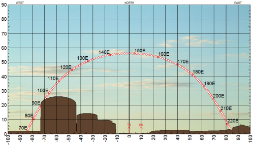
Sample GEOPoint Satellite Arc image with a horizon produced by HorizonProfile:
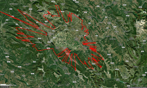
Sample MapList-Flat map image showing a horizon peaks map data produced by HorizonProfile:
HorizonProfile is intended for registered users of GEOPoint and LEOPoint.
There are no free features on this program.
Users must have a GEOPoint/LEOPoint registration code.
Registered users of GEOPoint/LEOPoint may enter their GEOPoint registration code into
this program to access the following PRO features:
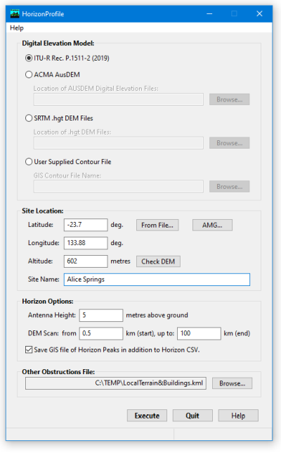
- Produce a 360 degree horizon profile, saved to a CSV file, based on accurate user supplied map data in a "Contour File" containing information on terrain contours,
and/or an "Obstruction File" containing height information for buildings, or other local terrain or obstructions around the antenna site, in common GIS file formats
(including KML, OSM, GeoJSON, GPX, MapList and AMG file formats).
- As an option to the user supplied Contour File, HorizonProfile can access terrain altitude information from three other Digital Elevation Model (DEM) sources.
- First DEM option, is the built-in ITU-R Recommendation P.1511-2 (2019) topography database,
which includes global terrain altitude data on a 5 minute latitude and longitude grid.
- For Australian sites, where the user has access to the ACMA AusDEM terrain database,
which includes Australian terrain altitude data on a 9 minute grid in latitude and longitude,
HorizonProfile can incorporate terrain information from this database into the horizon profile calculations.
The ACMA AusDEM database is not provided with HorizonProfile, but could be procured separately
from the Australian Communications and Media Authority (ACMA) using the
order form found here.
- The third, and preferred, DEM option is to use NASA SRTM HGT format DEM data files, which cover most of the earth's land mass (from 56°S to 60°N), with altitude data on a 3 second grid in latitude and longitude.
NASA SRTM data files are freely available online,
for example here.
Note that SRTM HGT files were not produced for map tiles that contain only sea.
If HorizonProfile asks for missing HGT files and you know those tiles are only sea, you can click Proceed to continue the calculation assuming all missing files are purely sea level altitude.
- The user may specify the antenna site by providing latitude, longitude, altitude, and antenna height above ground, or select
the antenna site from a list in a user supplied GIS file.
- Australian users may also enter antenna site coordinates using Australian Map Grid (AMG) coordinates.
- All horizon calculations take into account curvature of the earth and radio-wave refraction properties of the atmosphere in
accordance with ITU-R Recommendations.
HorizonProfile does not take into account diffraction, Fresnel zones, or other far field effects.
|